Saturday, May 20, 2017

Final Hazards Report


            Ecuador is a beautiful place to visit because it’s diverse topography and so much more. People come from all around the world to spend a once in a lifetime trip to see the Galapagos Islands, the only location in the world where many rare species of wildlife can be found. But for those interested in visiting Ecuador and those that already live there, it is very important to be aware of the potential hazards. Compared to most areas on the continent, the region is a bit more vulnerable to the potential risk of all natural hazards. But some are to be more concerned about then others, such as earthquakes.
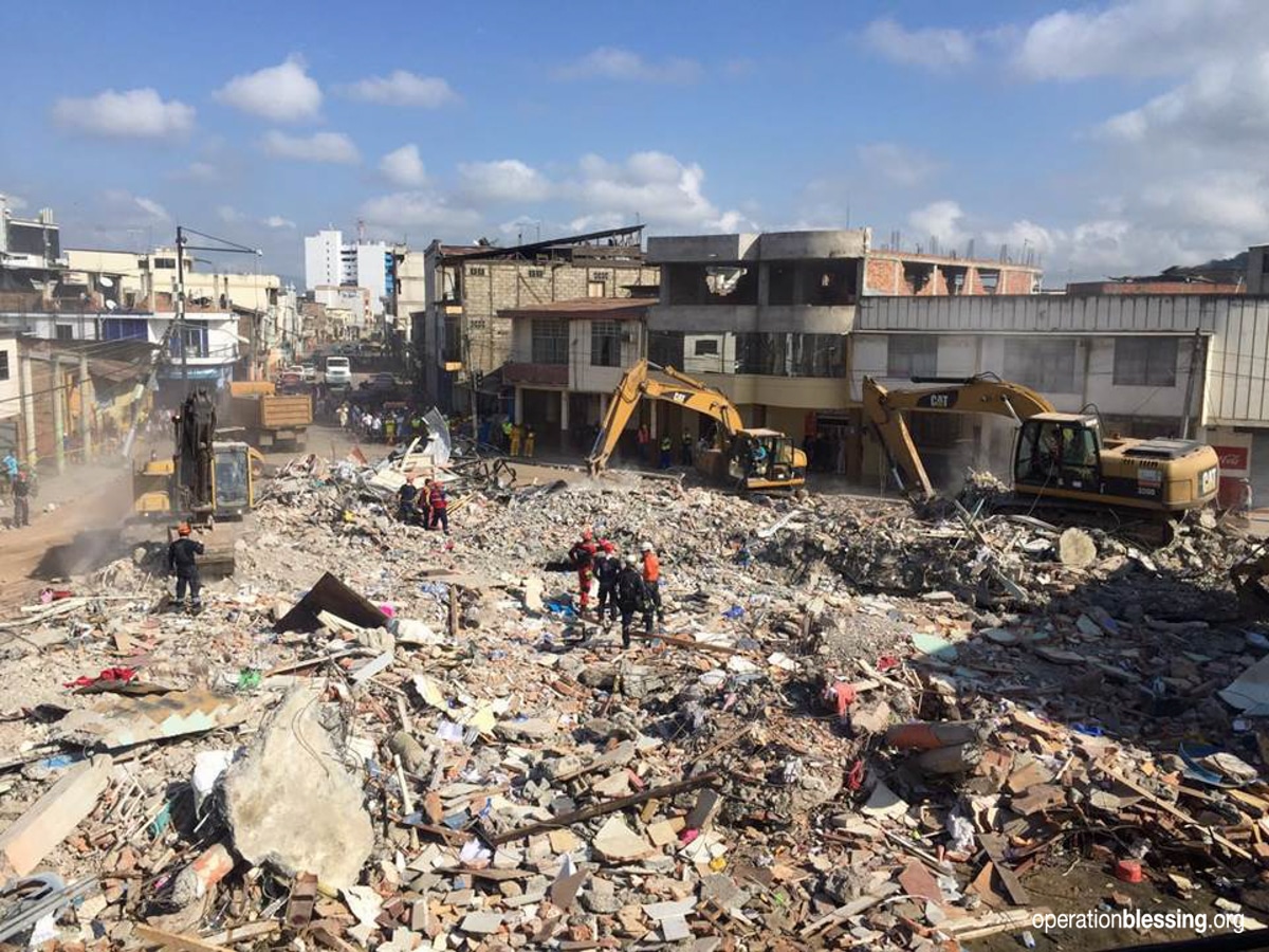
            The possibility of an earthquake occurring in the region is much more likely then that of any other hazard. If an excessively large quake were to occur the damage could be overwhelmingly catastrophic and it could also lead to other events such as a tsunami, and land/rockslides etc. As mentioned in a previous post, Ecuador is located above the Nazca Plate, which subducts beneath the South American Plate creating a thrust fault. At about 79mm per year, the Nazca Plate moves eastward towards the South American Plate. The Nazca Plate has produced the largest earthquake ever recorded by seismographs and it is constantly moving, carrying heavy risks and creating serious concern for those that are aware of the issue (like the government and geologists).
            Certain parts of Ecuador are more susceptible to damage caused by earthquakes or a tsunami. Areas on the coast such as the Esmeraldas down to the coast of Salinas are most definitely vulnerable to a tsunami if one were to occur. Going back to the risk of earthquakes, there are a few ways to mitigate damage caused by one that is very large. But with proper soils used as a foundation like Bedrock, and structures that are built with durable construction, damage can be avoided. By using soils such as Bedrock, damage is much less likely to occur to structures because the soil is dense and compact. This could also help prevent damage from flooding and other potential risks. It would be pertinent to focus on building specs that are near the coast first because they are at greatest risk of damage from an earthquake/tsunami.
            For those who want to build a house in Ecuador it would be strongly recommended to do it approximately fifty miles from the coast, like a location such as Quito. The location of Quito sits approximately 9,350 feet above sea level keeping it distant from any coastal hazards. As mentioned, new buildings must be built above bedrock and at least one to two hundred yards away from any hills that could eventually succumb to a land/rockslide. Ecuador would be a great place to build a home but doing so without any knowledge of the it’s natural hazards could lead to serious damage and/or death to the occupants within the home. That is why it is essential to be aware of these risks.  

References:


Friday, April 28, 2017

Coastal Hazards

Although tsunamis are rare, a large portion of Ecuador is right on the coast, making the region quite vulnerable to the possible hazard that can cause catastrophic damage. Because of the country's continental platform and location along the pacific rim, it is a frequent target for a tsunami. In total, 3 tidal waves classified as tsunamis have struck Ecuador since 1906, and four people have been killed because of the recent incidents. The worst happened in January of 1958, when a surface wave magnitude 7.6 struck, destroying 30 percent of the region. A total of 111 people were killed, and 45 were injured.

If a major tsunami were to occur, the cost of damage has been estimated to be roughly $441,000,000 - $620,000,000 in total due to the need of resettlement. These costs are also based on the possibility of four different scenarios if a powerful tsunami were to occur. There is a huge possibility that a very large scale earthquake could happen at anytime. This could generate the possibility of a tsunami striking Ecuador, but also other coastal regions thousands of miles away.

Discovering what the government of Ecuador is doing in order to mitigate a coastal casualty is challenging. The main focus of the government is growing the economy, unfortunately at the cost of the environment. Finding information online is the best way to prepare for a tsunami or any coastal hazard. As we have already discussed in class, knowing the possible risk that a tsunami could strike the coast at anytime is very important. Also, it is strongly recommended when visiting Ecuador to check in with hotel, or campground operators for tsunami information and how to be warned when one is likely to happen. The coast can be very dangerous after an earthquake, so it is pertinent to get as far away from the coastline after one occurs.

References:
 https://www.worlddata.info/america/ecuador/tsunamis.php

http://latinamericacurrentevents.com/ecuador-coast-high-risk-of-tsunamis-case-study-of-san-vicente/35308/

http://www.cwarn.org/tsunami/be-prepared

https://www.anywhere.com/ecuador/travel-guide/environmental-issues


Friday, April 7, 2017

Extreme Weather in Ecuador

The weather in Ecuador near the coast is often times very nice. In fact the temperature on average is around 77 degrees. But the region is still quite vulnerable to extreme weather especially because it is a coastal region. El Nino events take place quite often and these can lead to other hazards such as floods and landslides which can cause devastating damage. Because of environmental and socioeconomic challenges the country faces, climate change is also of concern because it can cause various different weather patterns. These patterns can lead to events such as droughts, floods, and intense rain fall, creating serious problems for agriculture and keeping crops maintained. There are quite a few studies that show the temperature in Ecuador is likely to increase over time due to climate change, especially because it's location is near the equator. Higher temperatures create a problem for the region because soil in most areas will be much drier, making it even more difficult for farmers to keep up their crops. Recently, Central America (including Ecuador) was hit with one of the worst droughts in its recorded history. The government had to invest more than $1.1 billion to protect citizens from weather-related disasters. Many leaders have made a point that these rapid weather changes must be discussed globally because a weather change in one region means a weather change in another, scary! It is important that authorities come together and have a serious discussion on what preventative matters to take. The time to do this is now.

References:

http://latinamericacurrentevents.com/climate-change-in-ecuador-expected-extreme-weather-events/23685/

https://www.un.org/press/en/2016/ga11851.doc.htm

Friday, March 17, 2017

Mass Wasting

Mass wasting as we know is often times not triggered by anything but gravity and the type of soil where they occur. Unfortunately with the amount and intensity of earthquakes in Ecuador, large land/rock slides are often triggered by them. Like earthquakes and volcanoes, mass wasting is a serious hazard for the country. With recorded landslides of 300 meters in length the only way to avoid these scenarios is to stay a long distance from where they could occur. When a large enough earthquake takes place in Ecuador, small to large landslides tend to take place at many different locations. On March 5, 1987 two earthquakes struck eastern part of the county, one a 6.1 magnitude, the other a 6.9. While some structural damage was caused by the quakes, even more damage was caused by mass wasting and flooding. A total estimate of 1 billion dollars was lost when this event took place. Causing buildings to collapse and blocking the path of the only highway from Quito to Ecuador's eastern rain forest and oil fields. The question is what can leadership do to prevent these hazards? Unfortunately these events are often inescapable and undetectable. But homeowners can prevent these situations by making sure their house is built on bedrock and not beneath any steep hills. Also, one who lives on a dwelling at the top of a steep hill must be careful to not add too much weight to the dwelling, such as swimming pool. This causes a greater pull of gravity, hence leading to a form of mass wasting. While not much information could be found on what authority is doing to mitigate these hazards, the fate lies in the hands of the homeowner who must decide if where they are living is safe. 

References:
https://www.nap.edu/read/1857/chapter/3#19

http://www.dailymail.co.uk/news/article-2724623/Ecuador-earthquake-triggers-huge-landslide-quarry-hillside-collapses-workers-killing-two-injuring-eight.html

http://www.scienceclarified.com/everyday/Real-Life-Chemistry-Vol-8/Mass-Wasting.html

Friday, February 24, 2017

Chimborzao
Cayambe

Volcanic Activity

Ecuador is a location with many volcanoes that are active but also inactive. Currently, there are a total of 25 volcanoes within the region itself. Due to subduction under the Nazca Pacific oceanic plate, (located under the continental plate of South America) these volcanoes belong to the Northern Volcanic Zone of the Andres.
The largest volcano is known as Chimborazo, a stratovolcano which is also known to be Ecuador's highest volcano. Recordings show this volcano has erupted at least 7 times within the past 10,000 years. Many have thought this volcano is currently dormant, but recent studies show that this volcano is in fact active.
Recently, Ecuador's Institute of Geographics (IGPEN) reported increased seismic activity at the Cayambe volcano. This is also a massive stratovolcano, located in the Northern part of Ecuador, near Quito. On June 5, 2016 geographers noticed the seismicity of the quake began to increase. According to Volcano Discovery, a seismic swarm of 2 300 earthquakes were recorded by the end of the month.
 Only one volcano known as Cotopaxi has actually erupted in Ecuador in the past 140 years. But this volcano is known to be one of the most dangerous in the world because it is surrounded by a densely populated area. After the Cotopaxi volcano erupted, surgical masks were distributed across a city of 2.3 million. Also officials became more alert in case of future events and are currently monitoring the volcano closely. If prompted to, authority's can have the city evacuated before an eruption.

References:
https://www.volcanodiscovery.com/cayambe.html

https://watchers.news/2016/12/07/cayambe-volcano-swarm-ecuador-2016/

http://www.telegraph.co.uk/news/worldnews/southamerica/ecuador/11804694/Volcano-erupts-in-Ecuador-for-the-first-time-in-140-years.html